A Brief History
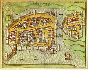
 Map of Limerick City, circa 1587
|
An early record of the name of Limerick is contained
in the Annals of the four masters, where in the year AD221 a battle, we
are told, was fought here. Over a century later, in the year AD334, the
Great Crunthaun, one of the most remarkable of the ancient kings of Ireland,
died here.
In the 9th century Luimenach was the name given to the lower Shannon,
but in 861 it ceased to be the name of the river and was thereafter usually
applied to the settlement on the island known as Inis Sibhton (King's Island).
|
| In AD900 Norse warriors called Vikings, led by one named Tomar, came
and settled here. They chose this location because it was the first place
on the Shannon that was fordable (at Curragour Falls) and was also on an
island (Inis Sibhton), formed by the Abbey River - a branch of the Shannon.
In 1197 the city was granted its charter by Prince John, Lord of Ireland,
who became King of England in 1199. He was a brother to King Richard the
Lionheart.
Limerick then is one of the oldest cities in these islands and was the
first in Ireland to appoint a mayor, namely, Adam Sarvant (1197-98) and
his bailiffs were John Bambery and Walter White. |
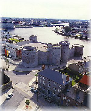
| King John's Castle was erected between c.1200
and 1207 and the original Thomond Bridge appears to have been built at
about that time also.
The building of the walls of the English Town on King's Island commenced
in the 13th century and when it was completely walled had a circumference
of 1.5 miles, encompassing 35 acres and was made up of the parishes of
St. Mary, Nicholas and Munchin.
Construction of the Irish Town began in the year 1310 and was completed
in 1495. Although different in shape from the English Town, its area and
circumference was roughly the same. Both towns were joined by Baal's Bridge
which was built at the narrowest point of the Abbey River in 1340. |
 King John's Castle, Limerick City
|
"Urbs Antiqua Fuit Studiisque Asperrima Belli"
- an ancient city well versed in the arts of war.
.
It is not known exactly when, or by whom, the city motto was first
decided upon, however, it is a quotation from Virgil's Aeneid and was quoted
during the time of the sieges in the mid 17th century. This adage describes
the place very well as from the time of the Vikings built the first settlement
in AD922, Limerick has been the site of many major battles. |
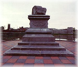
 The Treaty Stone, Clancy's Strand, Limerick City
|
Oliver Cromwell's son-in-law, Henry Ireton, kept
Limerick under siege in 1651. King William III's army did so in 1690 and
again in 1691, the latter culminating on the 3rd of October with the signing
of the Treaty of Limerick.
Tradition maintains that it was signed on the stone which is now mounted
on a pedestal, near Thomond Bridge, on Chancy Strand.
Click here for an indepth history
of the Sieges of Limerick 1690 - 1691 and the Treaty of Limerick |
Limerick was still a fortified city when John Pardon and Edmund Sexton
started work on the building of New Square, now known as St. John's Square.
This development which cost £630 was designed by Francis Bandana
and it was begun in 1751.
In 1760, Limerick was proclaimed an open city and the demolition of
the medieval walls began. Around that time the building of the Georgian
town known as Newton Pery started. The main leaders connected with this
movement were Pery, who owned most of the land, his brother-in-law Sir
Henry Harstonge, the Russell's and the Arthur's. Many streets are named
after these people and members of their families. The Newton was laid out
by Advise Ducat, an Italian designer and architect. Ducat also designed
the Custom House in Rutland Street, which was completed in 1769. The Newton
with its wide straight streets in gridiron pattern, was built rapidly.
Other buildings of this period were the Penal Chapels and the City Courthouse
in Bridge Street.
The Great Famine of 1847 did not affect Limerick to any great extent
as a result of the work of charitable organizations and also because the
people were not entirely dependent on potatoes.
Some of the prominent industries providing employment in the 19th Century
were those of leather, lace, flour milling, bacon, clothing, tobacco, brewing,
papermaking and milk processing.
In 1950 the city's boundaries were increased to 5, 115 acres and the
population is now in the region of 80,000 people (in the greater metro
area).
During the 20th Century, many of the traditional industries ceased trading.
These have been replaced by industrial estates catering for large and small
concerns.
The 1980's saw welcome developments in the area of new and renovated
buildings such as the refurbishment of the Granary, Michael Street, the
Potato Market, Merchant's Quay, the Bishop's Palace, Church Street, King's
Island, St. Mary's Cathedral and King John's Castle. Some of the more prominent
new buildings are the Civic Offices, Merhant's Quay, the Savoy, Henry Street/Bedford
Row and Arthur's Quay Shopping Centre and Patrick Street.
|